16th-20th May 2006
Hikers: George & Peter
We arrived at the Washington Towers campsite on the Tuesday afternoon and just managed to get the tents pitched before it started to rain. This was to be a similar situation for the next few days.
Day One
Distance:12.8 miles
Height Ascended:1,519 ft
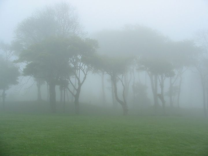
We awoke at 6:00 am to a real heavy mist and decided to have an extra hour of sleep and se if the mist clear. By 7:15 the mist was still quite thick, so we had breakfast and started to pack things away.
The first part of the walk was along a couple of main roads to get up on the Downs. Once on the Downs we had hoped that the mist would of cleared and we would have some views downs into the valleys but everything was shrouded in mist.
Our first point of reference was the trig point of Chanctonbury Hill but we missed it completely, which isn’t a real problem on the Downs as the paths are very easy to follow. The next point was Chanctonbury Ring, which is an ancient iron age fort but its main claim to fame these days are the beech trees. The Ring can normally be seen for miles around but not today as visibility was only about 20 yards. One minutes there was nothing and the next the trees of the Ring appeared.
The South Downs way is easy to follow even in mist but I did make a mistake in the map reading (talking to much) and followed a trail down into Bramber, which was about ½ mile North of where we should have been. This wasn’t too much of a problem as it got us out of the mist and we had a nice walk along the River Adur to pick the South Downs way up again.
After crossing the A283 we climbed up Beeding Hill, by the time we reached the up the mist had disappeared and we we had views back to where we had started from.
As the weather seemed to be clearing we decided to stop at the top for lunch and a brew.
One of the problems walking the Downs, this that most campsites are in the valleys; either North or South of the path, which means dropping into the valleys. Our campsite for tonight was to the North but first we had to continue up Truleigh Hill before descending to the village of Small Dole.
Small Dole is a pretty typical English village, a couple of Pubs, one local shop, and smattering of houses. The site we stayed on was part campsite, part farm.
Day Two
Distance 10.9 miles
Height Ascended:1,716 ft
After a good nights sleep; it was another early start. We were awake about 6:00 am and pottered about until 7:30 am and then set off.
As usual we had the gain the height that we lost yesterday, so it was a mile or so walk back to the bottom of the Downs at Edburton village and then a climb up to Edburton Hill. Once up; the Downs roll along with only the minimum of ups & down until reaching Devil’s Dyke.

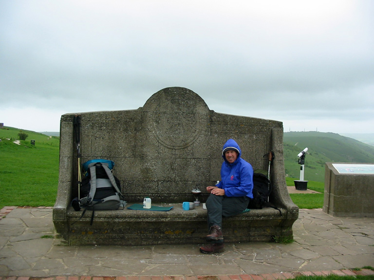
The wind had been picking up all morning and on reaching the Devil’s Dyke it was blowing quite strong, we managed to get on to the leeward side on one of the big concrete seats at the viewpoint and settled in and had a brew. At this point I was so cold I had to put on a fleece and gloves.
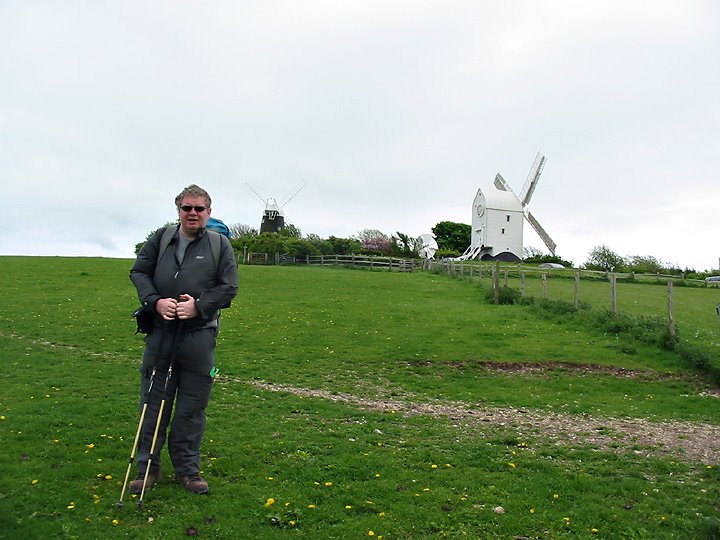
From the Devil’s Dyke the path continues East and there are a few descends down to the road and then back up again, one of the biggest is the descend to the A23 and then the climb back up to the Clayton windmills, which are named Jack & Jill. From the windmills it was another descent North and a further 2 miles to the campsite at Keymer.
A lot of campsites in the U.K. are on farms and this one was no exception, this one was also a large horse riding school with stables and large open paddocks. The campsite was in one of these paddocks.
During the night we had a big storm and the tents took a bit of a battering, at times my tent pole was bending at 50 degrees from the upright.
Day Three
Distance: 12.4 miles
Height Ascended: 535 ft
After a sleepless night and the wind howling across the site, we saw 2 or 3 tents that didn’t survive the night and have broken poles and ripped flysheets.
As the weather was so bad, we needed to change our plans, so we packed up and headed to a nearby café (we’d noticed the day before) and decided what would be the best route to take. Over a coffee and egg & bacon bap, we thought that the high route would be to windy, so we opted for a low level one instead.
The only problem with this, meant a 2 mile walk along the road to pick up a path to take us back Westwards.
We finally picked up a path at Hurstpierpoint and followed the paths across farmland and flood plains. We also passed under the A23 again only this time further North.
On this low level, we had good views back up onto the Downs, which are times were covered in low lying clouds.
Crossing one of the flood plains we came across about 20 bullocks blocking the path, and these animals then decided it would be fun to follow us across the field. This was a bit worrying as they were quite frisky and were barging into each other, we made it to the other side of the field with no mishaps though.
From there it was a mile along the road into Steyning and our last campsite. This site was outside the of the village and about ½ way up the hill which led back onto the Downs; and it was nice and sheltered.
That evening we walked back into Steyning to have a meal and a few beers in one of the pubs. On the way back the heavens opened and it was the first time on the whole trip we had to don waterproofs.
Day Four
Distance: 4.9 miles
Height Ascended: 896 ft
After a reasonable nights sleep; we woke to blue skies, unfortunately this wasn’t to last and by the time we left camp at 8:00 am the grey clouds had rolled is again.
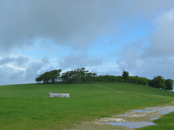
As we were already ½ way up on the Downs, we decided to take the high route, even though it was still windy; although not as bad a yesterday. So we climbed the rest of the way up Steyning Round Hill and rejoined the South Downs, this part was part of the Downs we had walked on the first day. This led us back to Chanctonbury Ring, which we got to see with no mist surrounding it. From the Ring we dropped of the Downs for the last time, mainly to the biting wind. The route then was mainly through farmland for a couple of miles until we were back at the car in Washington.
We were pretty lucky with the weather, it either rained at night or as most times after we had pitched the tents. The only real bad night was the Wednesday and this was probably one of the worse nights I have spent camping on the South Downs.
We only needed to wear waterproofs once and this was on the Friday night coming back from the pub.