Friday, 27 October 2006
Thursday, 19 October 2006
Another one found (blogger that is)
Another U.K blogger has appeared on the scene.
This time it's Alan Sloman's Big Walk
Alan will be setting off in March '07 to walk from Land's End to John O'Groats; some 1600 miles!
This time it's Alan Sloman's Big Walk
Alan will be setting off in March '07 to walk from Land's End to John O'Groats; some 1600 miles!
Monday, 16 October 2006
Digital Technology
In the past few years digital technology has really been a big help to walkers & hikers.
With the avent of the internet, we have been able to find out so much more information, throught the likes of dedicated websites such as walking forums, people's personal blogs and most recently podcasts.
We are also able to obtain equipment from virtually anywhere in the world (even if we do get clobbed with import taxes!!).
Digital cameras have given us the ability to have instant pictures, no more waiting a week for the prints to come back from the chemist and then being disappointed and wishing you could go back and try to capture the picture again (or is that just me).
Handheld GPS's are another way that digital technology is helping us, by being able to put us within a couple of metres of where we want to be, anywhere in the world.
The biggest piece of digital technology I have found useful are digital maps.
In the past; I would have to lay a map out across the kitchen table and then try to map out a route, use a map measurer to work out the distances covered. One area I could never work out was total ascent and decents mainly because I found it just to difficult.
Now with digital maps; I can plot a route on screen, I can change it and not have to re-measure the distance. I can check the total ascent & descent with the click of the mouse.
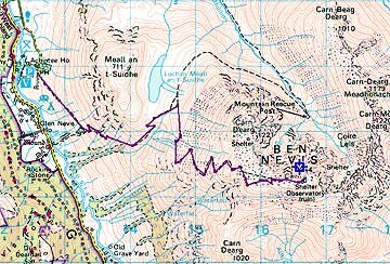
ROUTE:Car park to the top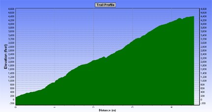
Profile
I don't have the problem where a route will go onto another map which I don't have, as digital maps are seamless. I also have the ability to save the routes and then download them into a GPS.
There are some drawbacks with digital maps, they are expensive (but in the long run you do save money). You can't buy the whole country in 1:25000, so it has to be 1:50000 but you can print out at different scales ranging form 1:1000000 to 1:10000, although the best scaling are either 1:50000, 1:25334 or 1:25000 but all the scalings are only enlargements of the 1:50000.
Another problem is that you can only print up to A4 in size.
Apart from these few small problems, digital maps are definitely the way to go.
Sunday, 8 October 2006
Gear used on Dorset trip
I thought I give a run down on the equipment I used on the recent trip to Dorset and how well it worked.
Tent
Terra Nova Solar. This is my favourite tent, more than enough room for one. Planty of porch space and headroom, I can sit up without worrying about my head touching the inner.
Best of all in the way that the porch doorway can be opened and give great views outside.
Backpack
Sixmoondesigns Comet. This pack has now replaced my G4, this a similar design and the three big pockets easily contain everything I need during the day, so I don't need to go into the inside of the pack.
Sleeping Bag
F&T Rolling Clouds 300 down bag. This is only the second trip I`ve used this bag on but so far its performed really well. It weighs just over 800 gms and although I never compress my bags it doesn't take up much room in my pack.
Sleeping Mat
This is one area where I made a mistake for the trip. As this was he first trip out since May, I decided to try a keep the weight down and decide to use my Artiach 3/4 length sleeping mat. The length of the mat wasn't a problem but I could feel the hard ground on my hips through it. In future I with be using my Isulmat Max-Thermo . It's heavier but I always get a good nights sleep on it.
Cooking Kit
My cooking kit consists of a Pocket Rocket Stove, 1 lexan spoon & fork, 2 non-stick pots (althought on this trip I only took one and regreted it), tin foil (to make a lid for the pots) and a plastic mug. The gas canister was a 100.
Other Kit
First Aid kit
Wash Kit
Waterproof jacket & trousers
T-A-R pillow
Spare socks & pants
Monatne windshirt
Fleece
Tikka Torch
1L platypus
Camera
Leki Poles
One other piece of equipment I didn't take on this trip was a MP3 player, which again I regreted.
All of this added up to 8.5 kg, without food and water.
Sometimes I think I get paranoid about the items and the weight I carry. Sometimes carrying the lighter equipment means I`m uncomfortable around camp.
If I was walking 20 mile days I probably find carrying the extra weight a problem but I never walk more than 15 miles, so I think the extra comfort in camp is better for me.
Saturday, 7 October 2006
Picture problems again
Blooger seems to be having problems when uploading pictures again :(
I`ve uploaded my pictures for the previous entry to Imageshack
This seems to work O.K but you do need to make sure the pictures are not wider than 5 in or it distorts the page.
I`ve uploaded my pictures for the previous entry to Imageshack
This seems to work O.K but you do need to make sure the pictures are not wider than 5 in or it distorts the page.
Two go camping in Dorset
3 1/2 days in Dorset
27th-30th September 2006
Hikers: Peter & George
Day One
Distance: 9.1 miles
High Ascended: 1194 ft
The trip was similar to one we did a couple of years ago following the
Purbeck Way. We started in Ridge just outside of Wareham.
We arrived about 5 pm on Wenesday and set-up the tents straight away. We then started on the wine :)
We woke to overcast skies and the forecast of rain, so we had a quick breakfast and packed up.
100 yards down the road and the rains started so it was on with the waterproofs and ready for a day of rain.
Luckily by the time we got to Stoborough Green the rain stopped and the Sun and blue skies re-appeared.
The walking was pretty easy on both the eye and the feet, as the terrain is open heathland.
Me on Creech Heath

Within a couple of hours we were in Corfe Village and made our way straight to the village bakery, in the bakery window was a notice proclaiming '3 bacon rashers in a bap £1.80' both Peter and I thought that would make a nice mid-morning snack.
Unfortunately they only had 3 rashers left but Peter could see I was flagging in a big way and allowed my to have them :) (Thanks Peter).
After our brunch stop, we made our way out of Corfe and up onto East hill.
Corfe Village from East Hill


Corfe Castle
Once we were up on the ridge of Challow Hill,Bollington Hill and Brenscombe Hill we had brilliant view back down to Corfe and over to Studland & Poole.

Studland & Poole
At Brenscombe Hill we decided that it was time for another Brew :)

Peter's tea break
From here we dropped down to Harman's Cross, where I nearly got run over. I was trying to get a picture of the steam train leaving Harman's Cross Station and going under the bridge and as the steam from the engine came up I stepped back into the path of a car, luckily he saw me and stopped.
From here we made out way the short distance to Woodyhyde Farm for our night's camp.
Day Two
Distance: 12.3 miles
High Ascended: 1960 ft
After a very rainy night; we woke to more rain. Today we were aiming for Tom's Field in Langton which as the crow flys is about 1 1/2 miles from Woodyhyde but we were going to do a big circuit.
As the weather was poor and still raining we don't start until 9.30 am. Out route for today was back to Harman's Cross and back onto the ridge, but because of the rain we decided to stay on the lower path of Ailwood Down. After about an hour's walking the rain stopped and the Sun was out, so off came the waterproofs.
We followed the path down to the road near Ulwell and then climb up to the Obelisk on Studalnd Hill and followed the ridge across to Ballard Cliff. All the while the weather was quite good and we had views downs to Studland and Swanage and across to the Isle of Wight. As we desended down Ballard Cliff the weather started to turn again so it was a rush to get into Swanage before the rain came again.
There is a point where the coatal path reaches the beach but the path continues up into the outskirts of Swanage and this is a plod into the town centre. This time we took to the beach and within 10 minutes were in the centre of town.
We made our way to somerfield s for lunch and then found a shelter to sit and eat it in. We also got our stoves out for a brew, which seemed to amuse the passers by.
By now the rain had set in again and the route around Durlston bay and Durlston Head didn't look to appealing. So we looked for an alternative route, we found one which went up through the town and then out to the open countryside.
The only problem with these routes through towns and housing estates, is that you get disorienated and lost :( After tramping around different allyways and small footpaths we finally found ourselves on the main road up to Durlston Head (Grrrr!!!).
We then made our way out to the lighthouse at Anvil point. As we have done parts of this route before and especially the coastal path, we stayed on the highier path and followed this before turning in land again to Langton and Tom's field.
Day Three
Distance: 9.1 miles
High Ascended: 726 ft
The Backpacker Club were having a static club meet at Tom's field for the weekend, so we said welcome to the members that were already there, and a few turned up as the night went on. One of the biggest disturbancies of the night was a group of ATC turning up and making a right royal racket. They also had one of the biggest tents I`ve ever seen, it was a khyam dome tent called the megatop.
After another poor night, we were up and away by 8.00 am. The route back today was following a couple of the paths we had already crossed. We made our way NE to Woodyhyde and picked up a path back into Corfe Village, where Peter was hoping to get his Bacon Bap today (unfortunately the Bakery didn't cook on a Saturday).

Peter without his Bacon Bap
From Corfe we took the path out over Knowle Hill and down to East Creech.

View from Knowle Hill
From there it was a couple of miles back through Furzebrook and Stoborough Heath to the campsite at Ridge.
27th-30th September 2006
Hikers: Peter & George
Day One
Distance: 9.1 miles
High Ascended: 1194 ft
The trip was similar to one we did a couple of years ago following the
Purbeck Way. We started in Ridge just outside of Wareham.
We arrived about 5 pm on Wenesday and set-up the tents straight away. We then started on the wine :)
We woke to overcast skies and the forecast of rain, so we had a quick breakfast and packed up.
100 yards down the road and the rains started so it was on with the waterproofs and ready for a day of rain.
Luckily by the time we got to Stoborough Green the rain stopped and the Sun and blue skies re-appeared.
The walking was pretty easy on both the eye and the feet, as the terrain is open heathland.
Me on Creech Heath
Within a couple of hours we were in Corfe Village and made our way straight to the village bakery, in the bakery window was a notice proclaiming '3 bacon rashers in a bap £1.80' both Peter and I thought that would make a nice mid-morning snack.
Unfortunately they only had 3 rashers left but Peter could see I was flagging in a big way and allowed my to have them :) (Thanks Peter).
After our brunch stop, we made our way out of Corfe and up onto East hill.
Corfe Village from East Hill
Corfe Castle
Once we were up on the ridge of Challow Hill,Bollington Hill and Brenscombe Hill we had brilliant view back down to Corfe and over to Studland & Poole.
Studland & Poole
At Brenscombe Hill we decided that it was time for another Brew :)
Peter's tea break
From here we dropped down to Harman's Cross, where I nearly got run over. I was trying to get a picture of the steam train leaving Harman's Cross Station and going under the bridge and as the steam from the engine came up I stepped back into the path of a car, luckily he saw me and stopped.
From here we made out way the short distance to Woodyhyde Farm for our night's camp.
Day Two
Distance: 12.3 miles
High Ascended: 1960 ft
After a very rainy night; we woke to more rain. Today we were aiming for Tom's Field in Langton which as the crow flys is about 1 1/2 miles from Woodyhyde but we were going to do a big circuit.
As the weather was poor and still raining we don't start until 9.30 am. Out route for today was back to Harman's Cross and back onto the ridge, but because of the rain we decided to stay on the lower path of Ailwood Down. After about an hour's walking the rain stopped and the Sun was out, so off came the waterproofs.
We followed the path down to the road near Ulwell and then climb up to the Obelisk on Studalnd Hill and followed the ridge across to Ballard Cliff. All the while the weather was quite good and we had views downs to Studland and Swanage and across to the Isle of Wight. As we desended down Ballard Cliff the weather started to turn again so it was a rush to get into Swanage before the rain came again.
There is a point where the coatal path reaches the beach but the path continues up into the outskirts of Swanage and this is a plod into the town centre. This time we took to the beach and within 10 minutes were in the centre of town.
We made our way to somerfield s for lunch and then found a shelter to sit and eat it in. We also got our stoves out for a brew, which seemed to amuse the passers by.
By now the rain had set in again and the route around Durlston bay and Durlston Head didn't look to appealing. So we looked for an alternative route, we found one which went up through the town and then out to the open countryside.
The only problem with these routes through towns and housing estates, is that you get disorienated and lost :( After tramping around different allyways and small footpaths we finally found ourselves on the main road up to Durlston Head (Grrrr!!!).
We then made our way out to the lighthouse at Anvil point. As we have done parts of this route before and especially the coastal path, we stayed on the highier path and followed this before turning in land again to Langton and Tom's field.
Day Three
Distance: 9.1 miles
High Ascended: 726 ft
The Backpacker Club were having a static club meet at Tom's field for the weekend, so we said welcome to the members that were already there, and a few turned up as the night went on. One of the biggest disturbancies of the night was a group of ATC turning up and making a right royal racket. They also had one of the biggest tents I`ve ever seen, it was a khyam dome tent called the megatop.
After another poor night, we were up and away by 8.00 am. The route back today was following a couple of the paths we had already crossed. We made our way NE to Woodyhyde and picked up a path back into Corfe Village, where Peter was hoping to get his Bacon Bap today (unfortunately the Bakery didn't cook on a Saturday).
Peter without his Bacon Bap
From Corfe we took the path out over Knowle Hill and down to East Creech.
View from Knowle Hill
From there it was a couple of miles back through Furzebrook and Stoborough Heath to the campsite at Ridge.
Two New Blogs
While I`ve been away, two new hiking blogs have appeared.
The first is Aktoman who is based in Scotland and has a Hilleberg Akto.
Like most of us, he seems to by a gear freak and has reviews of some of the new pieces of equipment he has bought.
The second one is Hike Wales.
This blog has information on hikes in Wales and equipment.
The first is Aktoman who is based in Scotland and has a Hilleberg Akto.
Like most of us, he seems to by a gear freak and has reviews of some of the new pieces of equipment he has bought.
The second one is Hike Wales.
This blog has information on hikes in Wales and equipment.
Subscribe to:
Posts (Atom)