With the avent of the internet, we have been able to find out so much more information, throught the likes of dedicated websites such as walking forums, people's personal blogs and most recently podcasts.
We are also able to obtain equipment from virtually anywhere in the world (even if we do get clobbed with import taxes!!).
Digital cameras have given us the ability to have instant pictures, no more waiting a week for the prints to come back from the chemist and then being disappointed and wishing you could go back and try to capture the picture again (or is that just me).
Handheld GPS's are another way that digital technology is helping us, by being able to put us within a couple of metres of where we want to be, anywhere in the world.
The biggest piece of digital technology I have found useful are digital maps.
In the past; I would have to lay a map out across the kitchen table and then try to map out a route, use a map measurer to work out the distances covered. One area I could never work out was total ascent and decents mainly because I found it just to difficult.
Now with digital maps; I can plot a route on screen, I can change it and not have to re-measure the distance. I can check the total ascent & descent with the click of the mouse.
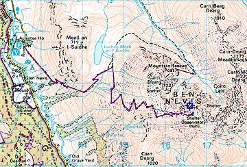
ROUTE:Car park to the top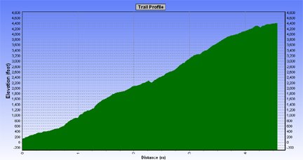
Profile
I don't have the problem where a route will go onto another map which I don't have, as digital maps are seamless. I also have the ability to save the routes and then download them into a GPS.
There are some drawbacks with digital maps, they are expensive (but in the long run you do save money). You can't buy the whole country in 1:25000, so it has to be 1:50000 but you can print out at different scales ranging form 1:1000000 to 1:10000, although the best scaling are either 1:50000, 1:25334 or 1:25000 but all the scalings are only enlargements of the 1:50000.
Another problem is that you can only print up to A4 in size.
Apart from these few small problems, digital maps are definitely the way to go.
Although Memory Map does not have full coverage at 1:25k, other digital mapping does, e.g. Tracklogs
ReplyDeleteThanks for the info dorset backpacker.
ReplyDelete